
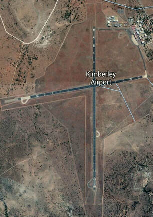
KIMBERLEY AIRFIELD SOUTH AFRICA


Airfield Coordinates
S284806 |
E0244549 |
Navigation
3.1 - nm - S - Kimberley |
KYV |
113.200 |
143° |
0.2nm |
Frequencies/Radio Navigation Aids
Bloemfontein - APP |
119.400 |
Kimberley - TWR |
118.200 |
Kimberley Apron |
122.650 |
KYV |
113.200 |
Runway Information / Elevation
RUNWAY |
02/20 |
3,000m x 46m |
Surface: Asphalt |
3,950 ft (137 hPa) |
RUNWAY |
10/28 |
2,439m x 46m |
Surface: Asphalt |
Visual Reporting Points
Barkley West |
KYV 344° / 20nm |
S283223 E0243157 |
Beilmont |
KYV 230° / 43nm |
S292530 E0242230 |
Boshoff |
KYV 081° / 29nm |
S283253 E0251418 |
Jacobsdal |
KYV 201° / 20nm |
S290759 E0244602 |
Perdeberg |
KYV 145° / 20nm |
S285900 E0250500 |
Plooysburg |
KYV 264° / 31nm |
S290223 E0241409 |
Windsorton Road |
KYV 016° / 28nm |
S282002 E0244220 |
Contact Information
Telephone |
053 830 7108 |
082 829 5556 |
Email |
Website |
http://www.acsa.co.za |

|

|